English English Chinese (Traditional) Danish Dutch Finnish French German Italian Portuguese Russian Spanish Swedish Japanese Catalan ¡Parajes del mundo...visítalos!
Pleyhades.com
  Home > Vall d'Aran Natural Park
Índice de Rutas


Vall d'Aran Natural Park
Map and Routes
The 
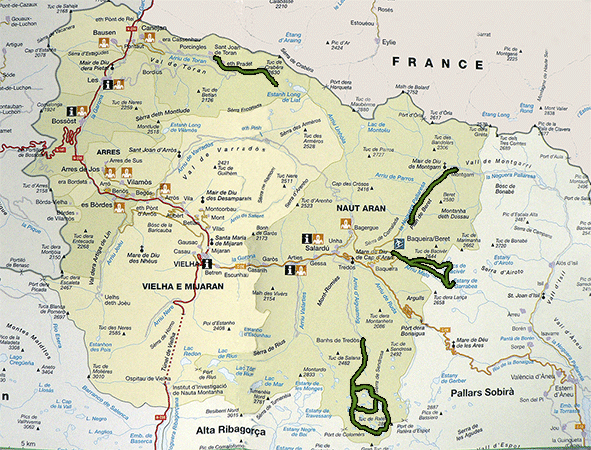
Vall d'Aran is at Northwestern of Catalonia, at north of the Pyrenees border with France and Aragon. It is an Atlantic valley over 620km2 extension on the Garona River, which flows into the Atlánico Ocean near Bordeaux. This is the only Atlantic valley at the Principat and emphasizes its unique climate, flora and fauna. Its origins and history have prompted a Occitan culture and language. The native official language of the Aranese people is named Aranes, a variant of Gascon, and belonging to the occitan family languages.
Mapa Vall d'Aran
The valley communicates with the Pallars by the Port of Bonaigua and with the Alta Ribagorça by the tunnel of Viella. It is surrounded by mountains over 3000m altitude, with the Bessiberri at south and the group of mountains of Maladeta with The Aneto at the Southwest. Also contains the birth of the rivers Noguera Pallaresa and Noguera Ribagorçana.
These natural barriers have constrained communication with the neighboring lands of Aragon and Catalonia, with inaccessible ports during the winter and the difficulties the rest of the year, while access to the French territory was easier just following the course of the river.
The current population (2007) is about 7500 inhabitants distributed in 30 clusters around the river Garona, with altitudes between 650m and 1430m. The capital is Viella and is at the heart of the valley with an altitude around 980m.
Nowadays Vall d'Aran is one of the most fashionable areas of the Pyrenees and attractive for winter tourism, as well as nature lovers attracted by the beauty of the landscape allowing, for almost the whole year, the practice of hiking and mountain sports. In addition, also attracts tourists culture lovers thanks to the charm of their rural communities, the interest of his art medieveal, the cuisine and the folklore.


Beret Montgarri Route
Card
Cross section of the Beret to Montgarri Route 
Location Vall d'Aran Natural Park
Departure Point Pla de Beret
Arrival Point Pla de Beret
Distance 9Km (roundtrip)
Approximate time 4h30m
Maximum height Pla de Beret- 1845m Unevenness 200m
Difficulty Low
Suitable time All year
Notes of interest Route near ski tracks, it is necessary to be well equipped in winter, because it is all snow-covered.
GPS >>Download Track<<


St Joan Toran = Pla Grauer Route
Card
Cross section of the St. Joan Toran = Pla Grauer Route 
Location Vall d'Aran Natural Park
Departure Point Honeria Forest Refuge
Arrival Point Pla de Grauer
Distance 9Km (roundtrip)
Approximate time 2h30m Outward - 1h:30 Inward
Maximum height Pla de Grauer - 1605m Unevenness 590m
Difficulty Low
Suitable time All year (except during snow)
Notes of interest -
GPS No


Route Lakes of Colomers
Card
Cross road lakes of Colomers 
Location Valley of Aiguamog. Valley of Arán
Departure Point Salardú, going throught the valley Arriu de Aiguamog, Plan de Banhs
Arrival Point Plans de Banhs
Distance 17Km (Total). Rountrip route, we start and arrive to Plan de Banhs
Approximate time 7h
Maximum height Coth deth Pòdo - 2600m Unevenness 1063m
Difficulty High
Suitable timet June - October
Notes of interest In diverse points of the route the road disappears; you must be watchfull to the signs located throughout the journey if we don't want to get lost.
GPS No


Lakes Colomers Short Route
Card
Lakes Colomers Short Route Cross road 
Location Valley of Aiguamog. Vall d'Aran
Departure point Colomers Refuge
Arrival point Colomers Refuge
Distance 4.5Km (Roundtrip).
Approximate time 1h
Maximum Height Lake Mort - 2200m Unevenness 100m
Difficulty Low
Suitable time May - October
Notes of interest There are some routes around the circus of Colomers and they begin at the Colomers Refuge, we have to take care about wich one are we taken because are not well signposted.
Once you've chosen the route, it's easy to continue along the route without getting lost.
GPS No
 
Contact with the administrator Unique Visitors: